Partnership working on East Riding of Yorkshire’s Strategic Flood Risk Assessment (SFRA) to inform climate resilient decision making.
An officer from the Environment Agency describes how they worked in partnership with the East Riding Council to undertake a Strategic Flood Risk Assessment (SFRA) for their district.
Why is a Strategic Flood Risk Assessment (SFRA) necessary?
Local Councils in their role as planning authorities are required to undertake a Strategic Flood Risk Assessment (SFRA) for their district. An SFRA assesses the risk from all sources of flooding; the cumulative impact that development or changing land use would have on the risk of flooding and the effect of climate change on risk.
SFRAs help various parties consider flood risk when making planning decisions about the design and location for any development, including flood risk management features and structures. SFRAs are used to inform planning for highways, transport, public health and economic growth.
What work did this partnership do?
The Environment Agency worked in partnership with East Riding of Yorkshire Council and their agents Capita to ensure the latest East Riding SFRA, published November 2019 – January 2020, gave good consideration to the potential impacts of climate change on flood risk in the district.
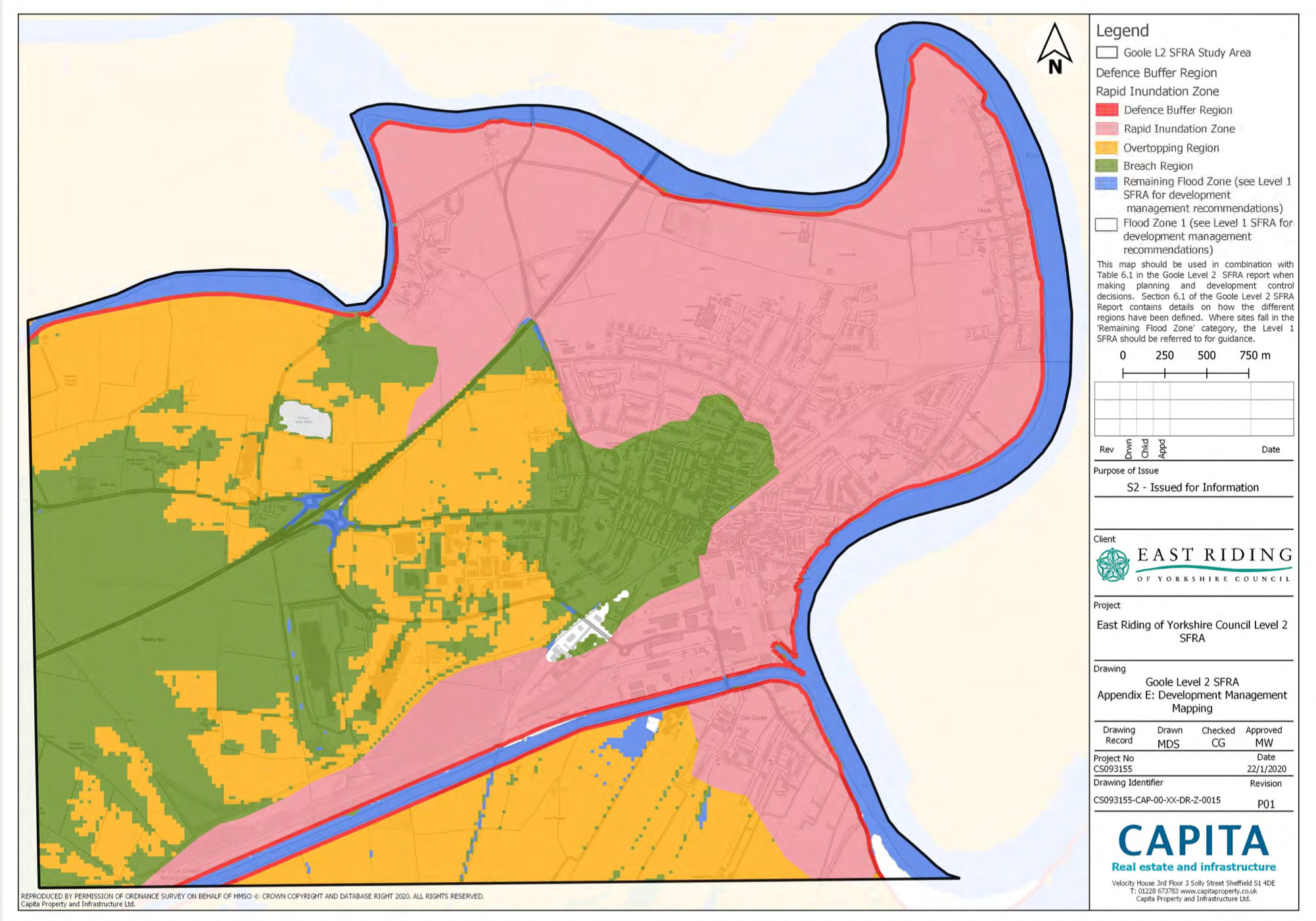
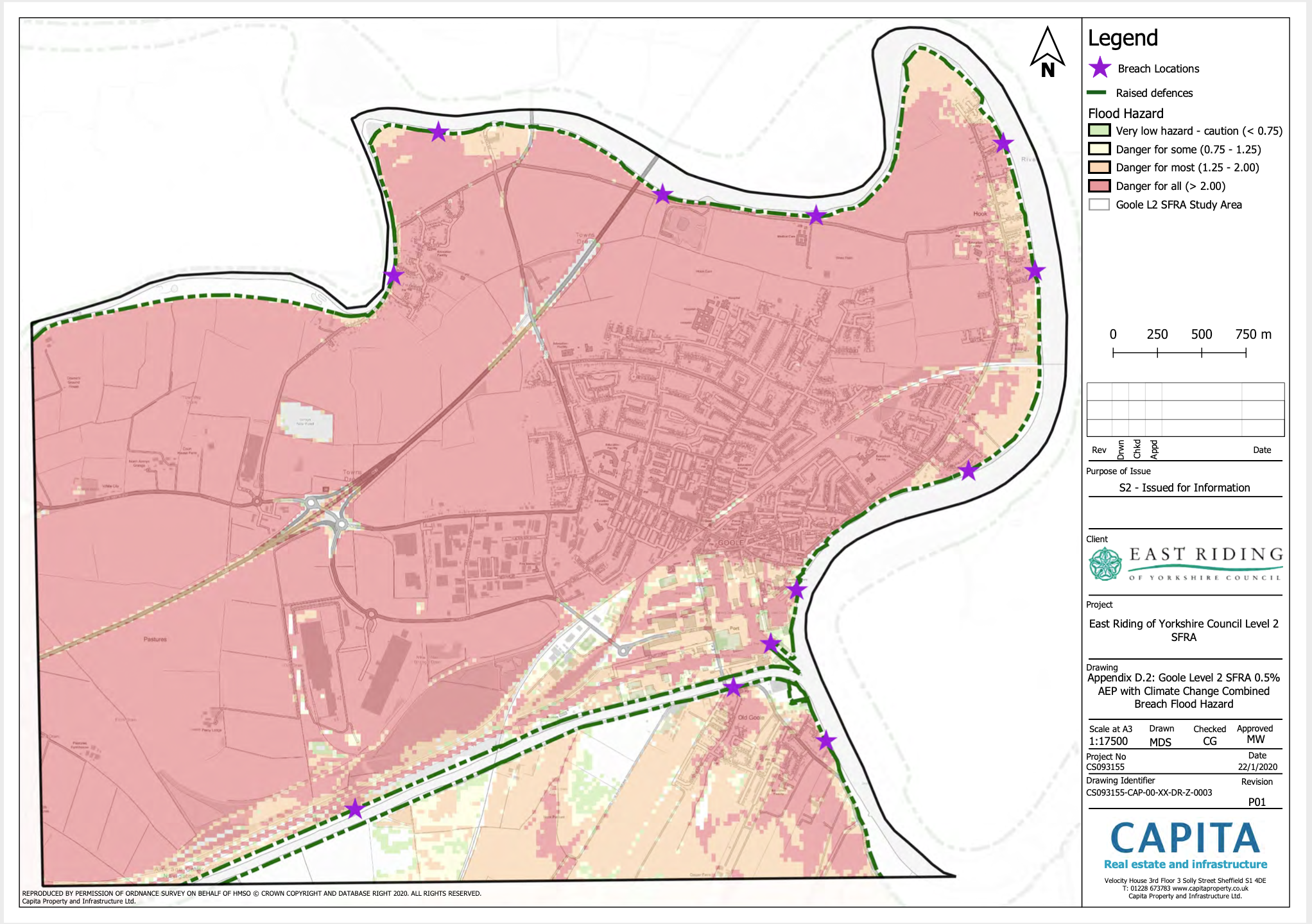
What do the maps show?
The two images show the area of Goole in East Riding. The image on the left below shows the current flood risk situation. The image on the right below shows what would happen under a climate change scenario were the defences to breach. The maps demonstrate the need to plan for resilience to climate change or the consequences of a flood event could be severe.
What are the benefits of the SFRA?
The East Riding SFRA highlights areas that are considered to be at low risk of flooding now, but are likely to be at medium or high risk in the future as a result of climate change. This allows design of development that is resilient to the effects of climate change even where that flood risk is not currently apparent.
The East Riding SFRA comprises 2 levels. Level 1 covers the entire authority boundary and aids planning decisions to avoid areas at flood risk wherever possible. The Level 2 covers the higher flood risk areas of Goole and Hedon. The SFRA aims to direct new development away from the highest flood risk areas in which new developments may not be sustainable in the long term in the face of climate change, or where the high levels of mitigation required to make new developments safe may make them unfeasible.
For those developments that must be located in areas of high flood risk the East Riding SFRA provides detail on appropriate climate change resilience measures to reduce as far as possible the flood risks to those developments into the future.
What is the role of SuDS in making places more resilient to the impacts of climate change?
The SFRA makes reference to the need for Sustainable Drainage Systems (SuDS) in new development and that wherever possible these should be designed in accordance with Ciria’s The SuDS Manual C753 to provide multifunctional benefits. Multi-benefit SuDS enhance spaces for people and nature and help to make places more resilient to the impacts of climate change.
Maps courtesy of East Riding of Yorkshire Council.